
Hurricane Ian moving through Central Florida as tropical storm
Hurricane Ian is producing “catastrophic flooding” across Central Florida as it churns slowly northward, the National Oceanic and Atmospheric Administration’s (NOAA) National Hurricane Center (NHC) reported at 7:00 a.m. CDT. Hurricane Ian came ashore along the southwestern Florida coast around 3:00 p.m. on Wednesday. The storm weakened overnight as it made its way overland and has been downgraded to a tropical storm. At 7:00 a.m. CDT, the center of Tropical Storm Ian was about 40 miles east of Orlando, Florida. Ian is moving toward the northeast near 8 mph. A turn toward the north-northeast is expected later today, followed by a turn toward the north and north-northwest with an increase in forward speed Friday and Friday night. On the forecast track, the center of Ian is expected to move off the east-central coast of Florida soon and then approach the coast of South Carolina on Friday. The center will move farther inland across the Carolinas Friday night and Saturday. Maximum sustained winds remain near 65 mph with higher gusts. Some re-intensification is forecast when it moves back across water, and Ian could be near hurricane strength when it approaches the coast of South Carolina on Friday. Weakening is expected Friday night and Saturday after Ian moves inland. Ian remains a powerful storm system with tropical-storm-force winds extending up to 415 miles from the center. Daytona Beach International Airport, far from the storm center, recently reported a sustained wind of 60 mph and a gust to 70 mph. The combination of storm surge and the tide will cause normally dry areas near the coast to be flooded by rising waters moving inland from the shoreline. Surge-related flooding depends on the relative timing of the surge and the tidal cycle and can vary significantly over short distances. Tropical storm conditions are occurring in parts of the warning area on the east and west coasts of Florida and should spread northward along Georgia, South Carolina, and North Carolina coasts today through Friday. Hurricane conditions are possible within the Hurricane Watch area in northeastern Florida, Georgia, and South Carolina through Friday. Widespread, life-threatening, catastrophic flash and urban flooding is occurring, with major to record flooding along rivers continuing across central Florida. Storm swells will increase along the coasts of Georgia, South Carolina, and North Carolina today. These swells are likely to cause life-threatening surf and dangerous rip currents on the Atlantic Coast. Governor Kay Ivey has pledged to provide support for the cleanup to Florida Gov. Ron DeSantis. Thousands of Floridians have evacuated to Alabama, and the state is opening shelters. Over a million homes in Florida are without power. Damage assessments will get underway later today when conditions improve. Residents and others are warned not to get out due to the risk of downed powerlines and still-rising floodwaters. To connect with the author of this story, or to comment, email brandonmreporter@gmail.com.
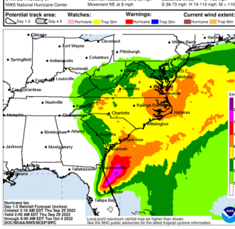
Hurricane Ian expected to do “catastrophic” damage to Florida coastal communities

The National Oceanic and Atmospheric Administration’s (NOAA) National Hurricane Center predicts that Hurricane Ian will create catastrophic storm surge, winds, and flooding in the Florida Peninsula when it comes ashore later today. At 7:00 AM CDT, the NHC reported that the eye of Hurricane Ian was located by Air Force and NOAA Hurricane Hunter data plus Key West radar about 55 miles west of Naples, Florida. Ian is moving toward the north-northeast near 10 mph. This general motion with a reduction in forward speed is forecast today, followed by a turn toward the north on Thursday. On the forecast track, the center of Ian is expected to move onshore within the hurricane warning area later this morning or early afternoon. The center of Ian is forecast to move over central Florida tonight and Thursday morning and emerge over the western Atlantic by late Thursday. Ian has maximum sustained winds remaining near 155 mph with higher gusts. Ian is a Category 4 hurricane and is forecast to make landfall on the west coast of Florida as a catastrophic hurricane. Weakening is expected only after it makes landfall. Hurricane-force winds extend outward up to 40 miles from the center, and tropical storm-force winds extend outward up to 175 miles. Hurricane conditions will begin along the west coast of Florida within the Hurricane Warning area later this morning. Tropical storm conditions have already begun in many areas along the Florida coast. Tropical storm conditions are expected in the warning area on the east coast of Florida beginning today and should spread up the Georgia and South Carolina coasts tonight and Thursday. Alabama should not experience severe weather from Ian. The Florida Keys and South Florida could get 6 to 8 inches, with local maximum of up to 12 inches from this storm system. Central and Northeast Florida should get between 12 to 18 inches, with local maximums up to 24 inches. Eastern Georgia and Coastal South Carolina could get 4 to 8 inches, with local maximums of up to 12 inches. Storm swells along the Florida, Georgia, and South Carolina coasts are likely to cause life-threatening surf and dangerous rip currents. Over 3 million Floridians were ordered to evacuate, and many of them have fled northward to Georgia and Alabama hotels and motels. There is also expected to be a temporary shortage of building materials as homeowners in Florida and Georgia rush to rebuild after the storm. The sudden demand will likely cause a spike in the prices for those goods lasting months, so please postpone any building or remodeling projects if possible. Alabama utility crews, along with those from other states, are poised to go to Georgia and Florida to assist with restoring electricity as soon as the storm passes through, To connect with the author of this story, or to comment, email brandonmreporter@gmail.com.
Hurricane Ian to make landfall on the Florida Coast

As of dawn on Tuesday, the latest National Hurricane Center forecast track for Hurricane Ian has nudged further eastward, which will take it into the coast around the Tampa Bay area within the next day. At this time, it appears that Hurricane Ian will be more of a Florida Peninsula event rather than a Florida panhandle event and is not expected to significantly impact Alabama. Ian is now over the western tip of Cuba. Winds have increased to 125 miles per hour, making Ian a category three hurricane. It is expected to strengthen to a category four hurricane once it gets back over the gulf waters. The latest NHC forecast track brings Ian into the coast near or just north of Tampa Bay tomorrow night. A Hurricane Warning is in effect for Bonita Beach to the Anclote River, including Tampa Bay. Remember that with a hurricane, the storm surge will affect a much wider range of the coast than will get landfall. A Storm Surge Warning is in effect for Anclote River southward to Flamingo and Tampa Bay. A Tropical Storm Warning is in effect for the lower Florida Keys from Seven Mile Bridge westward to Key West, Flamingo to Bonita Beach, Suwannee River to the Anclote River, Volusia/Brevard County Line south to Jupiter Inlet, and Lake Okeechobee. Ian is expected to only spend a few hours over western Cuba, so it is not expected to weaken in this short period over land. The eye of the storm should be over the southeastern Gulf of Mexico later this morning. While Ian will strengthen to a category four storm, the NHC is currently predicting it to weaken back to a category 3 when it comes ashore on the Florida coast near Tampa Bay. Florida residents are advised to stay out of the water due to life-threatening storm surge and the high likelihood of dangerous rip tides. Residents of the Florida coast from Fort Myers to the Tampa Bay region should listen to the advice given by local officials. Hurricane-force winds are expected in the hurricane warning area in west-central Florida beginning tomorrow morning, with tropical storm conditions expected as late today. Heavy rainfall will increase across the Florida Keys and South Florida during the day today, spreading into central to northern Florida tomorrow and Thursday and the Southeast by Friday and Saturday, likely causing flash, urban, and small stream flooding. Considerable flooding is expected across Central Florida into southern Georgia and coastal South Carolina, with significant, prolonged river flooding expected across central to northern Florida. Southwest Alabama is not expected to be heavily impacted by Hurricane Ian. The surf will be rough along the Central Gulf Coast as far west as Gulf Shores, including a high danger of rip tides. Parts of Alabama could see some rain from the remnants of the storm system this weekend, with a higher likelihood of rain on the eastern half of the state. Be aware that construction materials like plywood, roofing shingles, and lumber could be in short supply in the coming days and weeks, particularly if the damage is severe in Florida, so please postpone building and remodeling projects if possible so that supply chains can focus resources on what is likely to be a lengthy repair and rebuilding process in Florida. Alabama Today will continue to monitor the situation as conditions change. Please keep our friends in Florida in your prayers. To connect with the author of this story, or to comment, email brandonmreporter@gmail.com.
Barry Moore seeking to improve hurricane insurance protection for farmers

Rep. Barry Moore wrote a letter to Secretary of Agriculture Thomas Vilsack requesting an update on the Hurricane Insurance Protection – Wind Index Endorsement (HIP-WI) and amending it from an all-or-nothing system to a tiered system. After listening to stories from farmers about the losses they’ve suffered from hurricanes, Moore is asking for a more improved system of administrating hurricane insurance funds. Currently, the full value of a HIP-WI endorsement is only paid if a county or a neighboring county is within the area of sustained hurricane-force winds from a named hurricane based on data from the National Hurricane Center (NHC). Moore is requesting the system gets changed to a tiered system so that farmers can purchase protection from winds caused by a hurricane, even if the winds are below hurricane force in their county. “I know firsthand the damage that a hurricane can do to a farmer’s crops, and fortunately, in 2020, many counties in the Second Congressional District of Alabama were able to take advantage of the Hurricane Insurance Protection made available to them,” wrote Moore. “However, the counties that were not triggered by this all-or-nothing system still had extreme losses but were not eligible for HIP-WI. If the product was expanded to include a tiered system, farmers could purchase protection from devastating winds caused by a named hurricane, even if the winds are below hurricane-force within their county.” “We appreciate Congressman Moore’s steadfast support of farmers,” stated Mitt Walker, director of the Governmental and Agricultural Programs Department of the Alabama Farmers Federation. “He understands so much of what farmers face each growing season is completely out of their control, especially when it comes to weather events such as hurricanes. We appreciate his efforts to ensure farmers have a variety of risk management tools that are effective in their time of need.”
Alabama U-Haul locations offering free storage ahead of Tropical Storm Nate
As Alabamians prepare for Tropical Storm Nate, U-Haul is preemptively offering residents free self-storage for 30 days in facilities across the state to residents who stand to be impacted by the storm and the flooding it is expected to cause. “At this point, we are uncertain about where the storm will strike,” said Chadwick Rome, U-Haul Company of South Alabama president. “We want to proactively offer 30 days of free self-storage so that everyone is prepared. This is one way U-Haul can be a good neighbor to the communities we serve.” Tropical Storm Nate is currently making its way through the southwestern Caribbean and is forecast to strengthen into a hurricane that could affect the U.S. Gulf Coast. According to the National Hurricane Center, Nate could reach hurricane status as early as Saturday when it’s expected to enter the Gulf of Mexico. Its projected track shows it will make landfall as a weak Category 1 hurricane, with winds of about 80 mph, somewhere between New Orleans, and Mobile, Ala., sometime between Saturday night and Sunday morning. The U-Haul Companies of South Alabama, Central Alabama and Northern Alabama have made 26 facilities across 14 cities available to help. Families seeking self-storage assistance should contact the nearest participating facility (locations alphabetized by city): U-Haul Moving & Storage of Auburn 1301 Opelika Road Auburn, Ala. 36830 (334) 887-3412 U-Haul Moving & Storage of Birmingham 540 Valley Ave. Birmingham, Ala. 35209 (205) 942-6833 U-Haul Moving & Storage at Center Point 1636 Center Point Parkway Birmingham, Ala. 35215 (205) 854-7763 U-Haul Moving & Storage of East Lake 7733 First Ave. N. Birmingham, Ala. 35206 (205) 833-1208 U-Haul Moving & Storage of Fairgrounds 3028 Bessemer Road Birmingham, Ala. 35208 (205) 785-1524 U-Haul Moving & Storage of Mountainbrook 3195 Hwy. 280 Birmingham, Ala. 35243 (205) 262-9115 U-Haul Moving & Storage at Uptown 800 28th St. N. Birmingham, Ala. 35203 (205) 730-7821 U-Haul Moving & Storage at 6th Ave. 1802 6th Ave. SE Decatur, Ala. 35601 (256) 350-2955 U-Haul Moving & Storage at Montgomery Hwy. 1402 Montgomery Hwy. Dothan, Ala. 36301 (334) 794-6681 U-Haul Moving & Storage of Fultondale 1588 Carson Road Fultondale, Ala. 35217 (205) 608-1103 U-Haul Moving & Storage of Gadsden 1707 Kyle Ave. Gadsden, Ala. 35901 (256) 543-9502 U-Haul Moving & Storage at Putman Drive 4400 University Drive NW Huntsville, Ala. 35816 (256) 837-0203 U-Haul Moving & Storage at Sparkman Drive 1903 Sparkman Drive NW Huntsville, Ala. 35816 (256) 830-6464 U-Haul Moving & Storage at UAH Campus 4440 University Drive Huntsville, Ala. 35816 (256) 721-6995 U-Haul Moving & Storage of Bel Air 200 W. I-65 Service Road S. Mobile, Ala. 36608 (251) 343-7101 U-Haul Moving & Storage of Downtown Mobile 970 ½ Springhill Ave. Mobile, Ala. 36604 (251) 433-1548 U-Haul Moving & Storage of Springdale 3755 Airport Blvd. Mobile, Ala. 36608 (251) 344-0661 U-Haul Moving & Storage at The Loop 2507 Government St. Mobile, Ala. 36606 (251) 476-6548 U-Haul Moving & Storage of West End Montgomery 3138 Mobile Hwy. Montgomery, Ala. 36108 (334) 262-7701 U-Haul Moving & Storage of Woodmere 2525 Eastern Blvd. Montgomery, Ala. 36117 (334) 239-0471 U-Haul Moving & Storage of Oxford 523 Hamric Drive W Oxford, Ala. 36203 (256) 835-9152 U-Haul Moving & Storage at Pelham 2797 Pelham Parkway Pelham, Ala. 35124 (205) 663-3220 U-Haul Moving & Storage of Prattville 1221 S. Memorial Drive Prattville, Ala. 36067 (334) 380-4348 U-Haul Moving & Storage at Skyland Blvd. 124 Skyland Blvd. E. Tuscaloosa, Ala. 35405 (205) 349-1353 U-Haul Moving & Storage of Vestavia 1024 Montgomery Hwy. Vestavia Hills, Ala. 35216 (205) 822-4932 U-Haul Moving & Storage of Vestavia Hills 1420 Montgomery Hwy. Vestavia Hills, Ala. 35216 (205) 978-7587