The Alabama Emergency Management Agency (EMA) warns that severe weather across Alabama is possible from Wednesday afternoon through the early morning hours on Thursday. A second bout of severe weather is forecast for Friday is also possible.
Jim Stefkovich is an EMA meteorologist.
“Scattered showers and thunderstorms are forecast to develop across the state Wednesday afternoon into the early morning hours of Thursday,” Stefkovich wrote. “Between Hwy 80/I-85 and I-20, a couple of storms could produce large hail and straight-line wind gusts to 60 mph between 1 pm and 11 pm.”
“North of I-20, the threat will be longer duration, from 1 pm through 4 am Thursday, as an upper-level disturbance passes through the area,” Stefkovich continued. “Large hail, straight-line wind gusts to 60 mph, and heavy rainfall will be the threats. The tornado threat is minimal across the entire region, and widespread severe weather is not expected.”
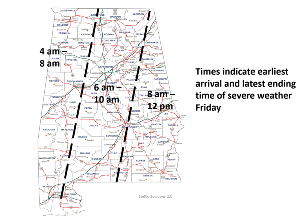
“The entire state is under a Slight Risk for severe weather Friday,” Stefcovich continued. “A very fast-moving line of storms ahead of a cold front will race across the state, entering the western portions between 4 am and 8 am and exiting the eastern sections by 12 pm. Due to how fast the line is moving, plus storms within the line moving at speeds near or above 60 mph, there is some concern for widespread damage as the high wind momentum is transported to the ground. There could also be a few tornadoes embedded within the line as well. Gusty winds of 30-40 mph will occur behind the front through early Friday evening.”
“Finally, heavy rainfall will occur north of I-20 Wednesday through Friday morning, especially near the AL/TN state line with widespread 1-3 inch totals and localized higher amounts,” Stefcovich warned. “This could produce some flash flooding.”
“Moist air returns and scattered showers and storms will form during the afternoon and evening hours. Where thunderstorms form, they will be strong with potential for hail and strong, gusty winds,” wrote meteorologist James Spann. “SPC (the U.S. Storm Prediction Center) has the northern third of the state in a “marginal risk” (level 1/5) of severe thunderstorms, and they have introduced a “slight risk” (level 2/5) for the northwest corner of the state.”
FRIDAY: We expect a fast-moving line of severe storms to move through the state Friday morning in the general window from 4 until 12 noon,” Spann explained. “SPC has most of the state (except the southwest corner) in a severe weather risk in their “Day 4” outlook.”
Alabama historically has a high risk of severe weather: strong thunderstorms, tornados, and flash flooding. Please stay weather aware this afternoon, tonight, and Friday morning. Be prepared to take shelter and have a plan if confronted with severe weather. Remember that with scattered storms, the weather may be fine (or not) where you are, and the situation is entirely different in a different part of the state or even just ten miles up the road, so be cognizant of weather updates and forecasts as you travel this week.
To connect with the author of this story or to comment, email brandonmreporter@gmail.com.