Hurricane Ian is producing “catastrophic flooding” across Central Florida as it churns slowly northward, the National Oceanic and Atmospheric Administration’s (NOAA) National Hurricane Center (NHC) reported at 7:00 a.m. CDT.
Hurricane Ian came ashore along the southwestern Florida coast around 3:00 p.m. on Wednesday. The storm weakened overnight as it made its way overland and has been downgraded to a tropical storm.
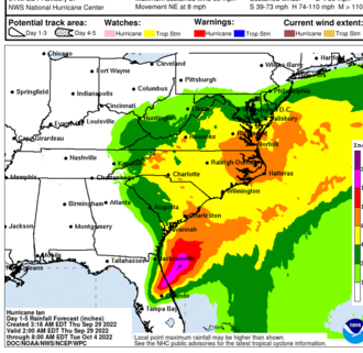
At 7:00 a.m. CDT, the center of Tropical Storm Ian was about 40 miles east of Orlando, Florida. Ian is moving toward the northeast near 8 mph. A turn toward the north-northeast is expected later today, followed by a turn toward the north and north-northwest with an increase in forward speed Friday and Friday night. On the forecast track, the center of Ian is expected to move off the east-central coast of Florida soon and then approach the coast of South Carolina on Friday. The center will move farther inland across the Carolinas Friday night and Saturday.
Maximum sustained winds remain near 65 mph with higher gusts. Some re-intensification is forecast when it moves back across water, and Ian could be near hurricane strength when it approaches the coast of South Carolina on Friday. Weakening is expected Friday night and Saturday after Ian moves inland.
Ian remains a powerful storm system with tropical-storm-force winds extending up to 415 miles from the center. Daytona Beach International Airport, far from the storm center, recently reported a sustained wind of 60 mph and a gust to 70 mph.
The combination of storm surge and the tide will cause normally dry areas near the coast to be flooded by rising waters moving inland from the shoreline.
Surge-related flooding depends on the relative timing of the surge and the tidal cycle and can vary significantly over short distances. Tropical storm conditions are occurring in parts of the warning area on the east and west coasts of Florida and should spread northward along Georgia, South Carolina, and North Carolina coasts today through Friday. Hurricane conditions are possible within the Hurricane Watch area in northeastern Florida, Georgia, and South Carolina through Friday.
Widespread, life-threatening, catastrophic flash and urban flooding is occurring, with major to record flooding along rivers continuing across central Florida. Storm swells will increase along the coasts of Georgia, South Carolina, and North Carolina today. These swells are likely to cause life-threatening surf and dangerous rip currents on the Atlantic Coast.
Governor Kay Ivey has pledged to provide support for the cleanup to Florida Gov. Ron DeSantis. Thousands of Floridians have evacuated to Alabama, and the state is opening shelters. Over a million homes in Florida are without power.
Damage assessments will get underway later today when conditions improve. Residents and others are warned not to get out due to the risk of downed powerlines and still-rising floodwaters.
To connect with the author of this story, or to comment, email brandonmreporter@gmail.com.
Related
Share via: